


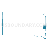
VTD-precinct 4B, Moody County, South Dakota
About
Outline

Summary
| Unique Area Identifier | 667662 |
| Name | VTD-precinct 4B |
| County | Moody County |
| State | South Dakota |
| Area (square miles) | 115.79 |
| Land Area (square miles) | 115.75 |
| Water Area (square miles) | 0.04 |
| % of Land Area | 99.97 |
| % of Water Area | 0.03 |
| Latitude of the Internal Point | 44.12880600 |
| Longtitude of the Internal Point | -96.59237550 |
Maps


Graphs
Select a template below for downloading or customizing gragh for VTD-precinct 4B, Moody County, South Dakota


Neighbors
Neighoring Voting District (by Name) Neighboring Voting District on the Map
- Altona Twp. Voting District, Pipestone County, MN
- Sweet Twp. Voting District, Pipestone County, MN
- Troy Twp. Voting District, Pipestone County, MN
- Verdi Twp. Voting District, Lincoln County, MN
- VTD-precinct 1, Moody County, SD
- VTD-precinct 11, Brookings County, SD
- VTD-precinct 16, Brookings County, SD
- VTD-precinct 3, Moody County, SD
- VTD-precinct 4A, Moody County, SD
- VTD-precinct 5, Moody County, SD
- VTD-precinct 8, Brookings County, SD
Top 10 Neighboring County Subdivision (by Population) Neighboring County Subdivision on the Map
- Medary township, Brookings County, SD (1,427)
- Flandreau township, Moody County, SD (372)
- Sweet township, Pipestone County, MN (324)
- Troy township, Pipestone County, MN (289)
- Fremont township, Moody County, SD (274)
- Verdi township, Lincoln County, MN (206)
- Union township, Moody County, SD (182)
- Trenton township, Brookings County, SD (174)
- Grovena township, Moody County, SD (173)
- Jefferson township, Moody County, SD (160)
Top 10 Neighboring Place (by Population) Neighboring Place on the Map
Top 10 Neighboring Unified School District (by Population) Neighboring Unified School District on the Map
- Brookings School District 05-1, SD (25,450)
- Pipestone Area School District, MN (7,718)
- Flandreau School District 50-3, SD (3,907)
- Colman-Egan School District 50-5, SD (1,663)
- Elkton School District 05-3, SD (1,467)
- Lake Benton Public School District, MN (1,395)
Top 10 Neighboring State Legislative District Lower Chamber (by Population) Neighboring State Legislative District Lower Chamber on the Map
- State House District 22A, MN (34,781)
- State House District 20A, MN (32,187)
- State House District 8, SD (20,647)
- State House District 4, SD (20,558)
Top 10 Neighboring State Legislative District Upper Chamber (by Population) Neighboring State Legislative District Upper Chamber on the Map
- State Senate District 22, MN (71,339)
- State Senate District 20, MN (66,816)
- State Senate District 8, SD (20,647)
- State Senate District 4, SD (20,558)
Top 10 Neighboring 111th Congressional District (by Population) Neighboring 111th Congressional District on the Map
- Congressional District (at Large), SD (814,180)
- Congressional District 1, MN (644,787)
- Congressional District 7, MN (625,512)
Top 10 Neighboring Census Tract (by Population) Neighboring Census Tract on the Map
- Census Tract 9587, Brookings County, SD (4,965)
- Census Tract 9586, Brookings County, SD (3,746)
- Census Tract 9596, Moody County, SD (3,313)
- Census Tract 9597, Moody County, SD (3,173)
- Census Tract 2010.02, Lincoln County, MN (2,801)
- Census Tract 4604, Pipestone County, MN (1,714)
- Census Tract 4601, Pipestone County, MN (1,643)
Top 10 Neighboring 5-Digit ZIP Code Tabulation Area (by Population) Neighboring 5-Digit ZIP Code Tabulation Area on the Map
- 57006, SD (24,530)
- 56164, MN (5,969)
- 57028, SD (3,448)
- 57026, SD (1,458)
- 57017, SD (1,340)
- 57002, SD (863)